Earthquake Cycle - Coseismic

​​More details to be provided soon

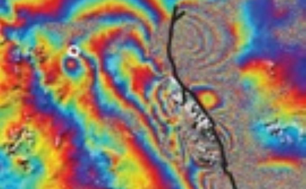
Large earthquakes cause thousands of casualties annually, but still the earthquake process is not very well understood. Scientists use a number of different observations and methods to study earthquakes. Geodetic data of coseismic deformation, for example, can provide detailed information about the location and geometry of earthquake faults as well as information about spatial variations of slip on the fault plane. Such information can be used to assess stress changes in the surrounding crust and to improve hazard assessments.​ ​

  • Sudhaus, H. and S. Jónsson, Source model for the 1997 Zirkuh earthquake (Mw=7.2) in Iran derived from JERS and ERS InSAR observations, Geophysical Journal International, doi: 10.1111/j.1365-246X.2011.04973.x, 2011.
  • Calais, E., A. Freed, G. Mattioli, F. Amelung, S. Jónsson, P. Jansma, S.-H. Hong, T. Dixon, C. Prépetit, R. Momplaisir, Transpressional rupture of an unmapped fault during the 2010 Haiti earthquake, Nature Geoscience, 3, 794-799, 2010.
  • Jónsson, S., H. Zebker, P. Segall, and F. Amelung,  Fault Slip Distribution of the 1999 Mw7.1 Hector Mine Earthquake, California, estimated from Satellite Radar and GPS Measurements, Bull. Seismol. Soc. Am., 92, 1377-1389, 2002.​